


Browse Topics
- Arts
- Buildings, Architecture & Monuments
- Business, Trade, Industry & Commerce
- Advertising
- Agriculture & Countryside
- Banks, Finance and Legal Services
- Domestic Service
- Innovation & Inventions
- International Contact & Trade
- Legal Services
- Printing and Publishing
- Shops & Retail
- Tourism and Hospitality
- Trades, Industries & Manufacturing
- Brass Trade
- Button Trade
- Carpet Making
- Ceramics and Pottery Industry
- Charcoal
- Chemical Industry
- Coins and Minting
- Engineering
- Glass Trade
- Gun, Sword and Weapons Trade
- Iron and Metal Trades
- Jewellery, Decorative and Toy Trades
- Mining
- Needle and Fish Hook Trades
- Pewter Industry
- Rope Industry
- Textile Industry
- Tools, Machinery and Equipment
- Unemployment
- Work, Pay & Conditions
- Culture & Diversity
- Events, Celebrations & Disasters
- Health & Medicine
- Religion, Ideas & Beliefs
- Science, Nature and Environment
- Society
- Sport & Leisure
- Transport
Transport
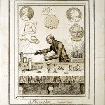
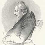
A Philosopher, Conduit Street
Image from: Joseph Priestley Collection by Samuel Timmins, Birmingham City Archives.
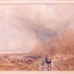
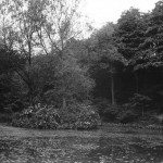
A Rainy Day
Watercolour undated, David Cox (1783-1859, b. Deritend, Birmingham – d. Harborne, near Birmingham). Wolverhampton Art Gallery. Gift… read more »
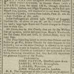
Aris’s Birmingham Gazette – Advert for transport between Birmingham and London
Safe and Elegant TRAVELLING. Hotel and Swan Inn, Birmingham. Paytons’s Old Original well-known LONDON POST-COACH, in Sixteen Hours… read more »
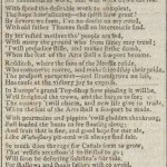
Aris’s Birmingham Gazette – SONG, on obtaining the BIRMINGHAM and WORCESTER CANAL BILL
SONG, on obtaining the BIRMINGHAM and WORCESTER CANAL BILL. Come, now begin delving, the Bill is obtain’d,… read more »
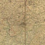
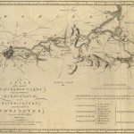
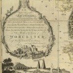
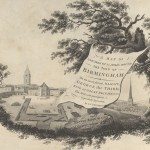
Birmingham and the Country Around, 1798
Image: ‘A MAP OF UPWARDS OF 25 MILES ROUND THE TOWN OF BIRMINGHAM. To his most sacred MAJESTY… read more »
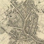
Birmingham in 1751
Image: This is a street plan from 1751, surveyed by Samuel Bradford and engraved by Thomas Jefferys. Samuel… read more »
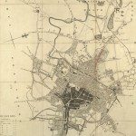
Birmingham in 1810
TO THE COMMISSONERS OF THE STREET ACTS, THIS MAP OF THE TOWN AND PARISH OF Birmingham, Showing… read more »
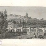
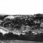
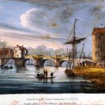
Bridgnorth, Shropshire
Image from: Picturesque Views and Descriptions of Cities, Towns, Castles, Mansions and other Objects of Interesting Features in… read more »
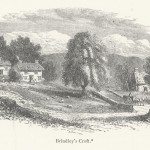
Brindley’s Croft
The birthplace of James Brindley was born at Tunstead, near Buxton in Derbyshire. Samuel Smiles, Lives of… read more »
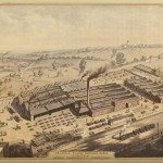
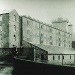
Britannia Railway Carriage Works, Birmingham
Image from: The New Illustrated Directory Entitled Men and Things of Modern England, 1858
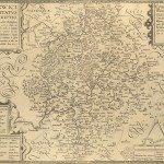
Canal Maps
Image: ‘PLAN of the intended NAVIGABLE CANAL from the TOWN of BIRMINGHAM into the RIVER SEVERN near the… read more »
Cartouches
Image: Cartouche from 1772 map of Worcestershire. Fruit is important to the agriculture of Worcestershire, and fruit of… read more »
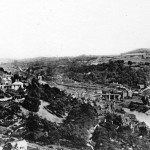
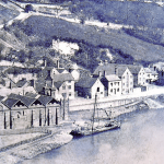
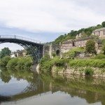
Charting the Severn Riverscape
Image: Ironbridge Gorge late C19. Photograph from J & S Slater’s Views of Ironbridge and District On… read more »
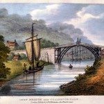
Colebrook Dale
Image:The Iron Bridge, near Coalbrookdale Shropshire. Thomas Harral, Picturesque Views of the Severn (1824). Harral’s views were largely based… read more »

Conclusion
Image Welch Bridge Shrewsbury. Thomas Harral, Picturesque Views of the Severn, 1824 The picture of the navigation that… read more »
Early Warwickshire Maps
Image: The ‘Anonymous’ map of Warwickshire Printed by John Overton of London. The date on it is… read more »
Francis Duke of Bridgewater
From Samuel Smiles, Lives of the Engineers, vol. I (London, 1904). From: Private Collection
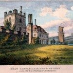
Holt Castle on the banks of the Severn
From Picturesque Views of the Severn, 1824 by Thomas Harral
Important Sources
Image: Large barge by Loadroft Wharf, Ironbridge, late c19 A surprising discovery came with the realisation that… read more »
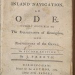
Inland Navigation
INLAND NAVIGATION, AN ODE. HUMBLY INSCRIBED TO The INHABITANTS of Birmingham, AND PROPRIETORS of the CANAL. The… read more »
Investigating the Severn
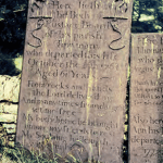
Image: Cast-iron memorial to trowman Eustace Beard at Benthall This is in part a personal story, but it… read more »
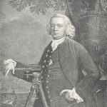
James Brindley, Canal Engineer
Portrait of James Brindley from Samuel Smiles, Lives of the Engineers, vol. I (London, 1904). Brindley is… read more »
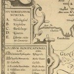
Keys and Explanations
Image: One of the earliest keys, from the late seventeenth century copy of the 1603 ‘Anonymous’ map. This… read more »
Keys and Explanations
Image: Key from map of Staffordshire, Phillips & Hutchings, 1832. Image from: Local Studies and History, Birmingham Central Library… read more »
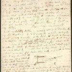
Letter from Erasmus Darwin to Matthew Boulton, 1764[?]
A detailed letter in which Darwin explains to Boulton his theory of a mechanically propelled car. —————————————-… read more »
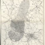
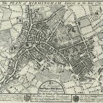
Map of the Mining and Manufacturing District of South Staffordshire, Warwickshire, etc.
William Hawkes Smith, Birmingham and its Vicinity as a Manufacturing and Commercial District (London and Birmingham, 1836).… read more »
Maps and Map Making: the West Midlands Experience
Image: Cartouche from James Sherriff’s map of the area for 25 miles around Birmingham, 1798. Image from:… read more »
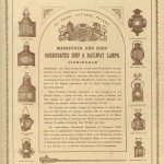
Messenger and Sons, Corrugated Ship & Railway Lamps, Birmingham
Image from: The New Illustrated Directory Entitled Men and Things of Modern England, 1858
Reflections on the Surface: reviewing the River Severn’s history
Image: Ironbridge in Telford Historians of the West Midlands have always recognised the importance of the River… read more »
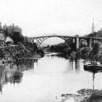
River Traffic
Image: Ironbridge Gorge late C19. Photograph from J & S Slater’s Views of Ironbridge and District In… read more »
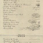
Shop goods and transit cargoes
Image: Beale’s Corner, Wribbenhall Between 1660 and 1730 port books portray the upstream trade in shop goods:… read more »
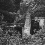
Snuff Grinding
Image: Snuff Grinding: ruins of the snuff mill, wooden gearing and water wheel, Golden Valley, near Tickenhill, Bewdley… read more »
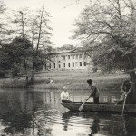
The Canal Wharf, Cromford, Derbyshire
The Cromford and Erewash Canal was built in the early 1790s as part of a route to… read more »
The Coal Trade
Image: Ironbridge Gorge late C19. Photograph from J & S Slater’s Views of Ironbridge and District Coal was… read more »
The Decline of Snuff Taking
Image: Upper Pool used as part of the snuff mill complex, Golden Valley, near Tickenhill, Bewdley (late 20th… read more »
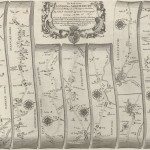
The First Road Maps, John Ogilby, 1697
Image:The road-map showing part of the route between London and Welshpool, from John Ogilby’s Britannia, published in… read more »
The Location of Ditherington Mill
Image: View of Ditherington Mill showing the Shropshire Canal and canal bridge in the foreground from an early… read more »
The Severn Trade
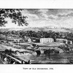
Image: Stourport locks (1770) This might seem a rich array of sources yet none covers the whole… read more »
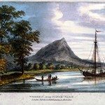
The Wrekin
Image: The Wrekin, from Cunde Park. One of the tallest hills in England, the Wrekin, a long-… read more »
Tithe Maps
Image: Tithe Map of Smethwick Image from: Birmingham City Archives Tithe maps mark the end of an era. From… read more »
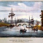
Understanding the Vessels
Image Stourport from below bridge. Thomas Harral, Picturesque Views of the Severn, 1824 Bringing together the many sources… read more »
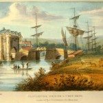
Understanding the watermen
Image : Gloucester Bridge and West Gate. Thomas Harral, Picturesque Views of the Severn, 1824 An increasing awareness… read more »
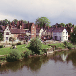
Varieties of Severn History
Image Bewdley from below the bridge. Thomas Harral, Picturesque Views of the Severn, 1824 Analysing the Severn Navigation… read more »

Village of Ashelworth, Gloucestershire on the banks of the Severn
From Picturesque Views of the Severn, 1824 by Thomas Harral
William Westley’s Plan of Birmingham, 1731
Image: The 1731 town plan of Birmingham bears this dedication: To the Honourable Edwd. Digby & Willm. Peyton… read more »
Work and Labour
Image: The Snuff Mill, Golden Valley, near Tickenhill, Bewdley (early 20th century) [Image from: Bewdley Museum] 2. Work… read more »